


The 2,000-Mile Alert: How the 2026 Polar Vortex Split Fueled a Rare Nor’easter
In January 2026, meteorologists watched a massive atmospheric disruption unfold nearly 20 miles above the Arctic Circle. A sudden spike in stratospheric temperatures shattered the polar vortex, sending frigid air spilling southward in a chaotic dance. This wasn’t just a cold snap; it was a signal—a 2,000-mile alert that a significant weather event was on the horizon.
Weeks later, that signal manifested as a ferocious Nor’easter that battered the East Coast of the United States. While winter storms are common in the Northeast, the 2026 event was different. It wasn’t born from typical seasonal patterns but was the direct offspring of a dramatic atmospheric breakup thousands of miles away. Understanding the mechanics behind this event reveals the delicate and powerful connections within our climate system.
This blog explores exactly how that stratospheric split occurred, why it fueled such an intense storm, and what the 2026 event tells us about the future of winter weather in a changing climate.
What Is the Polar Vortex and Why It Matters
To understand the storm, we must first understand the engine that drives Arctic weather: the polar vortex.
The polar vortex explained simply is a large area of low pressure and cold air surrounding both of the Earth’s poles. It exists year-round but weakens in summer and strengthens in winter. Think of it as a spinning top of frigid air, contained by a strong jet stream that acts like a fence, keeping the cold locked up in the Arctic.
When the vortex is strong and stable, the jet stream flows in a relatively straight line, trapping the coldest air up north. This is normal winter behavior. However, disruptions occur. When the vortex weakens or is disturbed, that “fence” becomes wavy. The spinning top begins to wobble. This allows cold air to dip southward into the mid-latitudes (places like the U.S., Europe, and Asia) while warm air pushes north.
It is important to distinguish between a standard cold snap and a vortex event. A cold snap might last a few days and be caused by a passing front. A true polar vortex disruption often leads to prolonged, deep freezes and can set the stage for explosive storm development, as we saw in 2026.
What Happened During the 2026 Polar Vortex Split
The catalyst for the 2026 storm began in the stratosphere, the layer of the atmosphere above where our daily weather happens.
In late December 2025, a phenomenon known as sudden stratospheric warming (SSW) occurred. Temperatures in the stratosphere above the North Pole jumped by as much as 50 degrees Fahrenheit in a matter of days. This rapid warming acted like a battering ram against the polar vortex.
Under this immense pressure, the vortex didn’t just wobble; it fractured. The 2026 polar vortex split resulted in the main body of cold air breaking into distinct “lobes” or daughter vortices. One lobe drifted toward Eurasia, while the other—the one that would eventually doom the U.S. East Coast—slid toward North America.
This split was massive, stretching the atmospheric disturbance nearly 2,000 miles across the hemisphere. It destabilized the jet stream entirely, creating deep troughs (dips) that allowed Arctic air to plunge much further south than usual. This specific configuration is a classic, albeit extreme, setup for severe winter weather.
How the Polar Vortex Split Set the Stage for a Nor’easter
The connection between a polar vortex Nor’easter is all about ingredients mixing in the wrong place at the wrong time. The split vortex provided the first ingredient: a massive injection of bone-chilling Arctic air.
As the North American lobe of the vortex settled over Canada, it pushed a deep trough in the jet stream down into the central and eastern United States. This created a boundary zone where the freezing dry air from the north collided violently with warm, moisture-rich air coming off the Atlantic Ocean.
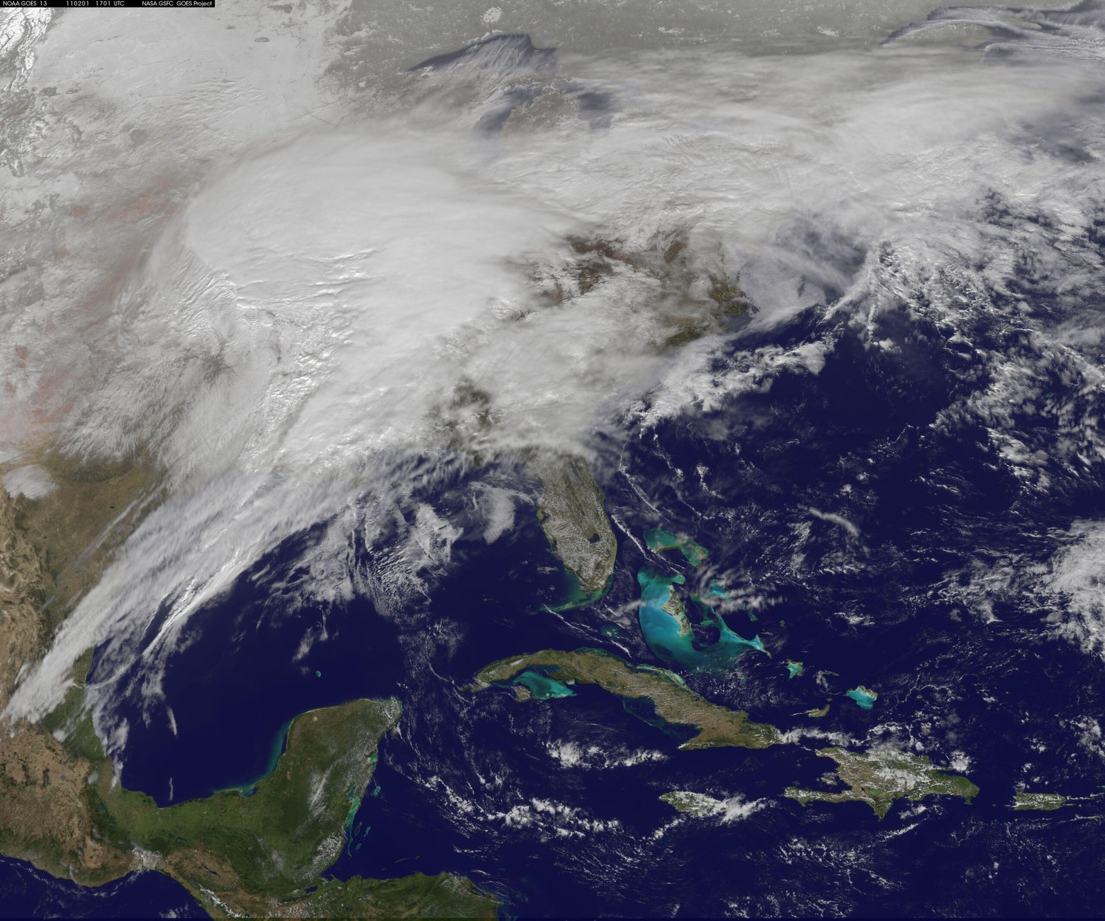
The jet stream disruption acted like a superhighway for storm systems. The sharp contrast in temperature created immense energy in the atmosphere. Pressure gradients tightened rapidly. A low-pressure system formed off the coast of the Carolinas and, fueled by the extreme temperature difference provided by the vortex split, underwent “bombogenesis”—a rapid drop in atmospheric pressure that signifies an intensifying storm.
Without the polar vortex split, the cold air likely wouldn’t have been deep enough or persistent enough to fuel a storm of this magnitude.
Why This Nor’easter Was So Rare
Nor’easters happen almost every winter, so why was this one labeled a rare Nor’easter USA event? The answer lies in the specific atmospheric alignment.
It is relatively common for the polar vortex to stretch or wobble. It is far less common for it to undergo a clean, sustained split that aligns perfectly with moisture feed from the Gulf Stream. In 2026, the timing was impeccable. The Arctic air arrived exactly as a disturbance in the southern jet stream was moving offshore.
Furthermore, ocean temperatures in the Atlantic were running above average. This provided extra fuel (heat and moisture) to the storm. The combination of record-breaking stratospheric disruption and high oceanic energy created a historic winter storm in the Northeast.
Meteorologists compared the 2026 setup to the great blizzards of the past, noting that while the storm track was familiar, the atmospheric forcing from the stratosphere was unusually strong, persisting for weeks rather than days.
Regions Most Affected by the 2026 Nor’easter
The Nor’easter impact areas were widespread, covering a massive swath of the eastern seaboard.
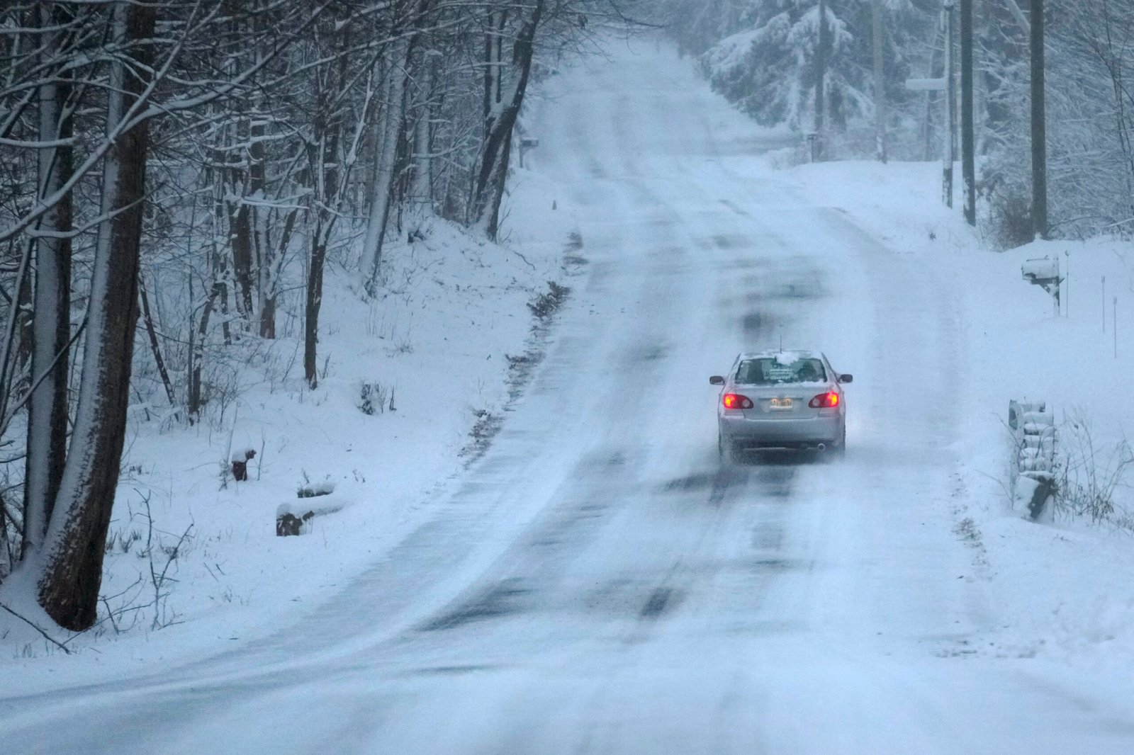
The Northeast winter storm 2026 hammered the classic I-95 corridor. Cities from Washington D.C. to Boston found themselves in the crosshairs. However, the impacts varied significantly depending on geography.
Inland areas, away from the warming influence of the ocean, faced the brunt of the cold air delivered by the vortex. Places like interior Pennsylvania, upstate New York, and western Massachusetts saw the highest snowfall totals because the cold air was locked in place.
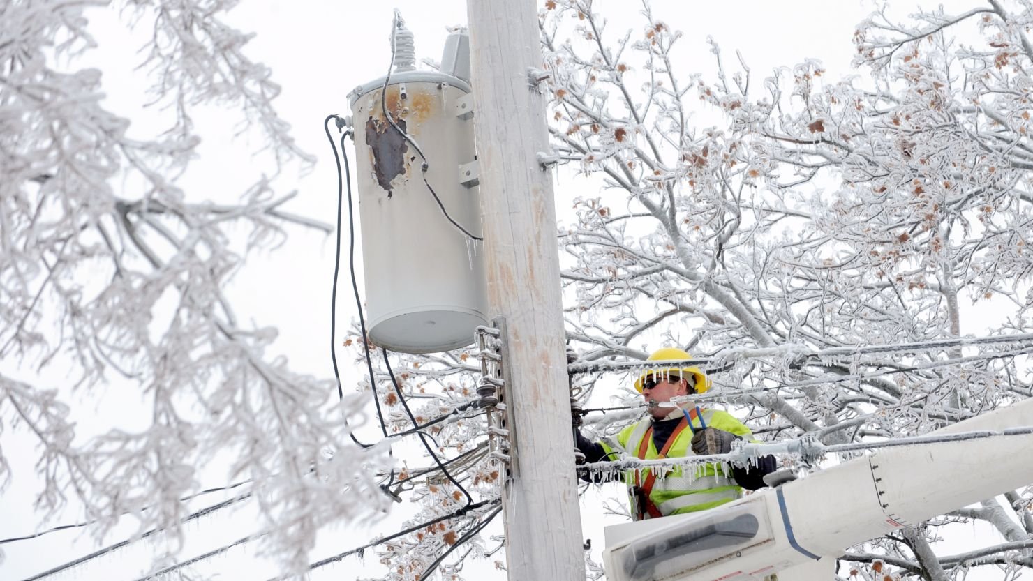
Conversely, the immediate coastline faced a different beast. The intense pressure gradient created hurricane-force wind gusts. While they received less snow, coastal communities dealt with battering waves and significant flooding. The urban corridor—including New York City and Philadelphia—sat right on the battle line between rain, ice, and heavy snow, leading to a logistical nightmare of changing precipitation types.
Snow, Wind, and Coastal Flooding Explained
The power of the storm was evident in the Nor’easter snow totals. Some inland higher elevations recorded over 30 inches of snow in less than 24 hours. The snow came down in heavy “bands,” narrow corridors of intense precipitation where snowfall rates exceeded 3 to 4 inches per hour.
These bands created dangerous blizzard conditions. The combination of heavy, falling snow and strong winds reduced visibility to near zero, paralyzing travel across multiple states.
Along the coast, the story was water and wind. Coastal flooding winter storm impacts were severe due to the storm’s slow movement and the timing of the lunar tides. The persistent onshore winds piled water into bays and inlets, causing erosion and inundating low-lying neighborhoods. Wind gusts topped 70 mph in places like Cape Cod and Long Island, leading to widespread power outages as trees, weighed down by wet snow or ice, snapped onto power lines.
Why Forecasting This Event Was So Challenging
Predicting the weather is hard; predicting the fallout from a stratospheric split is even harder. Winter storm forecasting challenges were highlighted during this event.
Computer models struggle with the timing of polar vortex prediction. While they can see a split happening in the stratosphere, translating that into specific surface weather weeks later is tricky. There is a “lag time” between the event in the upper atmosphere and the storm on the ground.
During the 2026 event, models disagreed significantly on where exactly the cold air lobe would settle. Would it center over the Great Lakes? Or would it drift further east? A shift of just 50 miles could mean the difference between rain and a historic blizzard for millions of people.
Furthermore, the storm intensified rapidly near the coast. This rapid deepening is notoriously difficult to forecast with precision. The warning windows were short for some coastal areas regarding the severity of the storm surge, leaving emergency managers scrambling to update evacuation orders.
How This Storm Compares to Past Polar Vortex Events
Looking at polar vortex history USA, the 2026 storm shares DNA with other famous winters.
It drew comparisons to the winter of 2013-2014, which introduced the term “polar vortex” to the general public. Like that winter, 2026 saw persistent cold. However, the 2026 event was more similar to the 2010 “Snowmageddon” in terms of storm track and moisture availability.
Past Nor’easter comparisons show that while 2010 had deep snow, the 2026 storm had higher wind speeds and more significant coastal impacts due to the specific orientation of the split vortex. What made 2026 distinct was the “cleanliness” of the split; the separation of the vortex was text-book, leading to a very predictable, albeit severe, release of cold air, even if the storm track itself was hard to pin down.
Lessons learned from earlier outbreaks helped. Utilities were better prepared for the cold, and cities pre-treated roads more aggressively, likely mitigating some of the travel chaos seen in previous decades.
Does Climate Change Influence Polar Vortex Behavior?
This is the big question. Climate change polar vortex connections are a subject of intense scientific study and debate.
The Arctic is warming much faster than the rest of the planet, a phenomenon known as Arctic Amplification. Some scientists argue that as the temperature difference between the Arctic and the tropics shrinks, the jet stream weakens. A weaker jet stream is wavier and more prone to disruptions, potentially making polar vortex splits more frequent.
This theory suggests that extreme winter weather trends—like deep freezes and massive snowstorms—are paradoxically linked to global warming. Warmer oceans provide more moisture for storms, while a destabilized vortex provides the cold trigger.
However, atmospheric dynamics are complex. Other studies suggest the vortex might strengthen in some climate scenarios. The 2026 event adds another data point to this ongoing research, suggesting that even in a warming world, the atmosphere is capable of generating profound cold and powerful winter storms.
What This Means for Future Winters
The 2026 event serves as a reminder that future winter storm risk remains high. We cannot assume that warming global temperatures mean the end of severe winter weather. In fact, we may face a future of “weather whiplash,” where mild winters are punctuated by sudden, extreme vortex-driven storms.
For extreme weather outlook USA, this means infrastructure must be resilient to both heat and extreme cold. Power grids need to handle spikes in winter demand. Coastal communities need to prepare for winter storm surges, not just tropical hurricanes.
The lesson is that “rare” might be a moving target. As the climate system adjusts to new baselines, the mechanics that drive storms like the 2026 Nor’easter may occur with different frequencies or intensities.
How Residents Can Prepare for Polar-Driven Storms
Preparation is the best defense against polar vortex safety tips.
Residents should learn to recognize the early warning signs. When news reports mention “Sudden Stratospheric Warming” or a “disrupted polar vortex,” understand that severe weather could follow in 2-4 weeks.
Winter storm preparedness checklist:
- Home: Insulate pipes to prevent freezing. Check your heating system before the season starts. Have a backup heat source if possible.
- Supplies: Keep a 3-day supply of non-perishable food and water. Have flashlights, batteries, and portable chargers ready for power outages.
- Travel: Avoid travel during the height of these storms. If you must drive, keep an emergency kit in your car with blankets, sand (for traction), and jumper cables.
Frequently Asked Questions (FAQ)
What does a polar vortex split mean?
A polar vortex split occurs when the large area of low pressure and cold air over the pole breaks into two or more smaller pieces. These pieces, or “lobes,” can move south, bringing Arctic conditions to regions that are typically more temperate.
How often do polar vortex splits occur?
Major splits don’t happen every year. They typically occur every other year or every few years. Minor disruptions are more common, but a full, deep split like the one in 2026 is a significant meteorological event.
Can a polar vortex split cause multiple storms?
Yes. Once the vortex is disrupted, the jet stream can remain “blocked” or wavy for weeks. This can create a pattern where multiple storms ride the same track, leading to a chain reaction of bad weather.
Was this Nor’easter predictable days in advance?
Meteorologists knew weeks in advance that the conditions for a storm were high due to the vortex split. However, the specific track of the Nor’easter—who would get rain vs. snow—was only confident about 3-5 days before impact.
Are Nor’easters becoming more intense?
Data suggests that while the total number of storms may not be increasing significantly, the intensity of the strongest storms is rising. Warmer oceans provide more energy, leading to heavier precipitation and stronger winds when storms do form.
Final Thoughts — A 2,000-Mile Warning Sign
The 2026 Nor’easter was a powerful reminder of the interconnectedness of our planet. A temperature spike 20 miles above the Arctic triggered a cascade of events that buried American cities in snow and flooded coastlines.
The atmosphere gave us plenty of signals. The 2,000-mile alert of the polar vortex split provided a window into the mechanics of our changing climate. As we move forward, understanding these polar dynamics matters far beyond the Arctic. The 2026 storm may redefine what we consider “rare,” forcing us to adapt to a world where the weather is wilder, less predictable, and capable of delivering profound surprises.